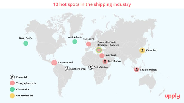
Some shipping areas present particular risks to the smooth flow of containerised liner shipping, for a variety of reasons. An overview of these hot spots.
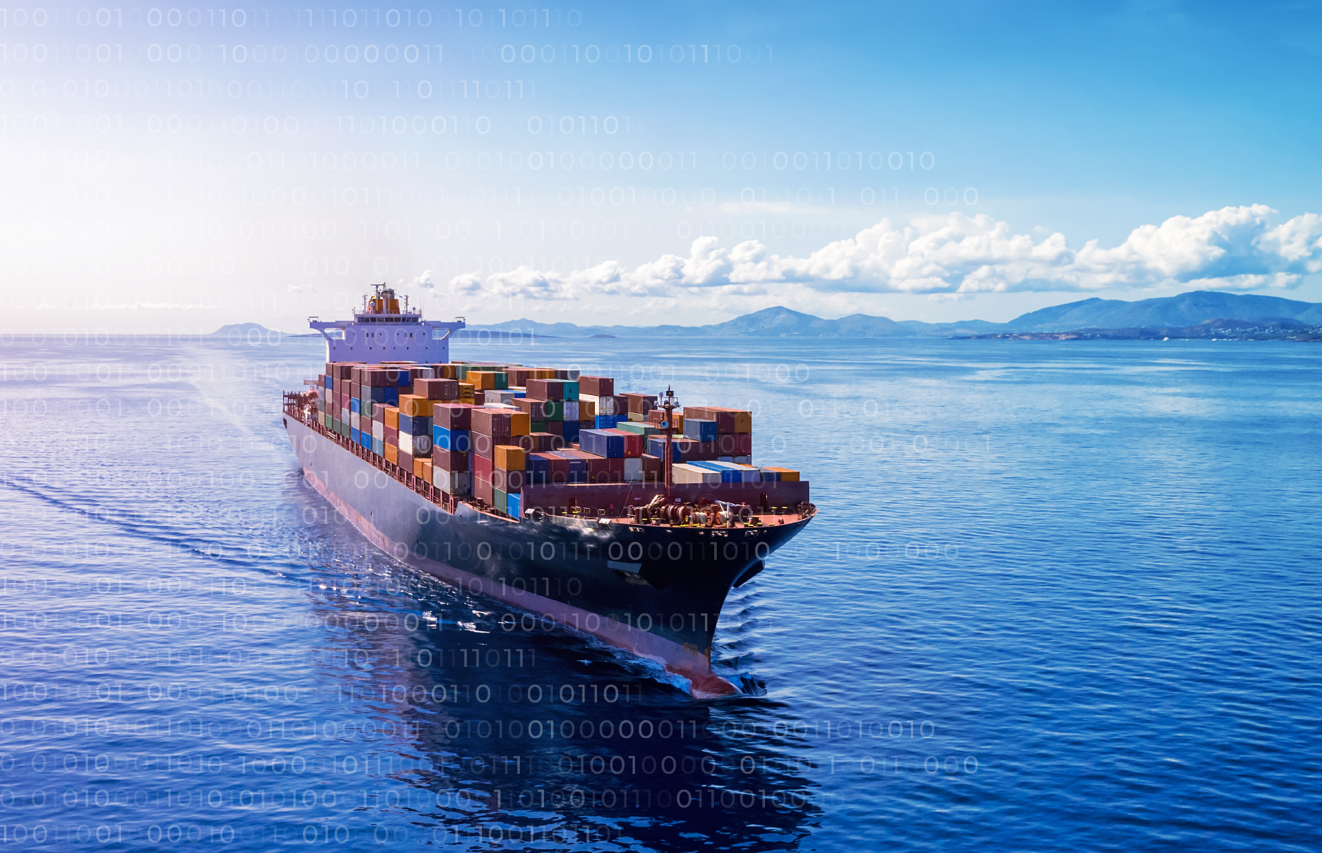
The efficiency of containerised liner shipping depends on the regularity and fluidity of services. However a grain of sand can quickly cause the machine to seize up, with serious consequences, as we saw when the Ever Given ran aground, paralysing shipping in the Suez Canal for several days. As this incident has shown, certain areas are particularly strategic, but also vulnerable, whether for topographical, political, climate or even criminal reasons. These are important factors to take into account in a supply chain risk analysis.
We therefore wanted to offer our readers a list of the main hot spots on the planet that we have identified, deliberately limiting ourselves to 10. We have also assigned each zone an overall risk index. Please note that this index is not the result of a compilation of data, but an estimate by the author based on their knowledge of the market.
© Upply.
1/ The Strait of Malacca
A vital link between East and West via Singapore, the Strait of Malacca accounts for around 35% of the world's containerised maritime traffic. The principal danger in this area is the very high level of traffic through such a narrow passage, which creates a sort of permanent bottleneck. The cohabitation of all types of ships of all nationalities, plus inshore fishing vessels, requires constant vigilance and fairly slow speeds.
This slower rate of sailing encourages piracy and armed robbery. In 2022, the number of incidents worldwide decreased from 172 to 131, according to the International Maritime Organization's Annual Report 2022. However the Straits of Malacca and Singapore account for more than half of these incidents, and have recorded an increase in 2022 (72 incidents compared with 70 in 2021). Attacks occur particularly in the areas at both ends of the Strait.
2/ The Gulf of Aden
As the gateway to and from the Suez Canal via the Red Sea, this crossing point geographically funnels vessels into a perfect trap, wedged between Yemen on its northern bank, a country that is politically quite unstable, and Somalia to the south, the scene of numerous armed conflicts between clans. The Gulf of Aden has always been a hotbed of piracy. Marauders can target their prey in a restricted space. To combat this phenomenon, the European Union has set up Operation Atalanta, which was extended last year until 31 December 2024.
China is also gaining a growing foothold in the region, using this geographical link as a strategic entry point into Africa for its Southern Silk Road.
3/ The China Sea and Taiwan Strait
In a deliberate effort to simplify the subject, we are including the East and North China Seas to adopt the Chinese vision of the 9-dash line or "cow’s tongue line".
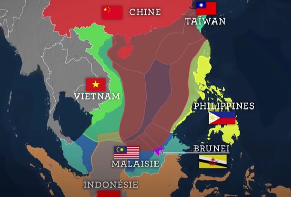
Source: Chine : la mer, la puissance et le (non) droit - Le Dessous des cartes, ARTE
Politically, China does not recognise the exclusive economic zones (EEZs) set out in the UNCLOS Convention, creating a permanent risk of maritime conflict with neighbouring countries. The epicentre of the tension is between mainland China and Taiwan, where incidents are occurring more and more frequently and are becoming increasingly serious. There is a real fear that one side or the other will slip up or make a false move. Furthermore, the China Sea is not immune to piracy.
Finally, this area is also hit by violent coastal typhoons, which are becoming more intense as a result of global warming.
4/ The Gulf of Guinea
Bordered by eight African countries with very different economies, this area suffers from rampant piracy. In addition to coastal attacks on merchant ships, there is the risk of attacks on the high seas by highly organised networks. 71% of incidents in this region now occur in international waters, according to the International Maritime Organization's Annual Report 2022. Hostage-taking of ships and crews, racketeering of all kinds, make this an area overtaxed by marine insurers, and this is now done on a structural basis.
5/ Winter navigation in the Atlantic and North Pacific
The risk associated with sailing in these areas is mainly a well-known and long-standing climate risk: in winter, ships have to contend with severe lows and dangerous, very high, cross seas. The smallest ships, which are common on the Transatlantic crossings, are subject to very high levels of list, and inadequate stowage inside containers often has fatal consequences.
Since the early 2000s, there has been a growing trend in container losses at sea. On the positive side, improvements in navigation and weather forecasting systems have reduced the risks. The shipping companies have also introduced measures that seem to be paying off, since the statistics are showing a slight improvement. However, the risk remains significant, especially given the increase in extreme weather events linked to the accelerated warming of ocean temperatures.
6/ The Solent
Despite technological advances, this access route to the port of Southampton remains a complex navigational area for the mega ships. In poor weather conditions, strong winds and currents reduce manoeuvrability, which is already limited by the geography of the area. Intense maritime traffic and the many rocky spurs represent a major risk, especially in the event of partial or total loss of propulsion. The Isle of Wight forms a natural "stopper" to the mouth of the port of Southampton ("Soton" as it's nicknamed). This configuration was an ideal natural geographical and military bastion for the English fleet at the time of its domination of the oceans. Today, however, this is more of an obstacle to the development of container terminals. In comparison, the prominent neighbouring port of Le Havre has ideal access to the Port 2000 terminals.
7/ Northern Brazil
A former 'artisanal' coastal piracy zone, Northern Brazil now presents a more limited risk for container ships. Piracy is tending to spread more actively to the coasts of Colombia and the Caribbean region. As the coast is relatively unsupervised and not particularly active, it is advisable to remain vigilant, even if the trend is for this risk to recede.
8/ The Panama Canal
Despite maximum safety guaranteed by the Canal's competent authorities, their pilots and their towing service, there is no shortage of hazards. Serious damage is rare, but minor incidents are frequent, especially with the largest vessels that were built to the maximum canal gauge. Since 2016, following widening works, vessels with a capacity of 14,000 TEUs have theoretically been able to use the Panama Canal. However, in view of the severe drought that affected the region this summer, the authorities have imposed a draught limit and restricted the number of vessels authorised per day. These measures are set to last for a year, unless there is a major increase in the water supply in the meantime. The race to outdo each other in terms of ship size between China and the East Coast of the United States is therefore no longer on the books. The use of smaller vessels with more modest draughts should limit the risks for as long as the water shortage persists.
9/ The Suez Canal
As is often the case with human behaviour, it takes a major catastrophe to change things. The costly warning issued by the Ever Given misadventure (and the situation could have been far more catastrophic if all or part of the vessel had had to be unloaded on site...) seems to have been heeded. Better training for young pilots, as well as more systematic and compulsory use of tugboat assistance, should greatly improve the success of this high-precision navigation. Crossing the canal is like threading a needle (a 24,000 TEU ship is 400 metres long and 60 metres wide). Nevertheless, collisions are still all too common in the area, and the incidents reported since the Ever Given affair show that the risk remains.
10/ Dardanelles, Bosphorus and Black Sea
This busy area currently poses many risks. In addition to the intangible topographical risk associated with the physical restrictions of the Bosphorus Narrows, there is now the risk of military incidents with the large Russian fleet, drifting mines and the over-militarisation of the area around the exit corridors for wheat.
Furthermore, last August, violent fires in Turkey, worsened by the drought, blocked shipping in the Dardanelles Straits, demonstrating that the climate risk also exists in this region.
Finally, in the Black Sea, the risk of a military incident getting out of hand is probably the biggest threat.